On Sunday morning, as the most of the city was asleep I decided to wake up and do some cooking before going out for
my hike. I love early morning, so I set my alarm for 3:30AM, but as
usual the voices inside my head were telling me too early, too dark
to be up this early, so I slept in till 4 before starting my day,
there was some light towards the east. First on the agenda was to
prep food for the week so I have tasty meals and a hardy breakfast.
This morning's menu: spicy chicken & veggie stir-fry in peanut
sauce and some BBQ chicken for sandwiches.
 |
| Breakfast of Champions, Spicy Chicken & Veggies in Peanut Sauce |
 |
| The base to my amazing chicken, bacon, spinach & cheese sandwiches for the day's hike |
Once breakfast was cooked up, I packaged up meals for
the early part of the week and started getting ready for the long day
ahead. I went through the checklist to make sure I wasn't missing
anything: 2L water bladder, 2 x 500mL water bottles with electrolyte
tablets (lemon-lime for the day), first-aid kit, wet wipes (just in
case nature calls), gloves, headlamp (you never know), compass,
trekking poles, camera, dates, Ritz peanut butter sandwiches,
Toblerone & BBQ chicken, bacon, cheese and spinach sandwiches
(yummy). Oh can't forget the cooler with some watermelon & cold
water for afterwards.
Loaded up the car and made my way out for the day. I
was meeting Sean, Kyndra & Nani at Cypress to do the Howe Sound
Crest Trail all the way to the Lions to bag some peaks. We all
arrived within minutes of each other and started our way along the
Howe Sound Crest Trail.
 |
| The beginning of the first climb |
 |
| The Lions, our turnaround point |
The first peak to bag was St. Mark's Summit, about
5.5km from our starting point, with some elevation change, about
460m. The hike up was amazing with quite a few views of Howe Sound
and the Lions. Once we were at the summit it was beautiful and we
even got to hang out with a raven. Kyndra has a special relationship
with ravens.
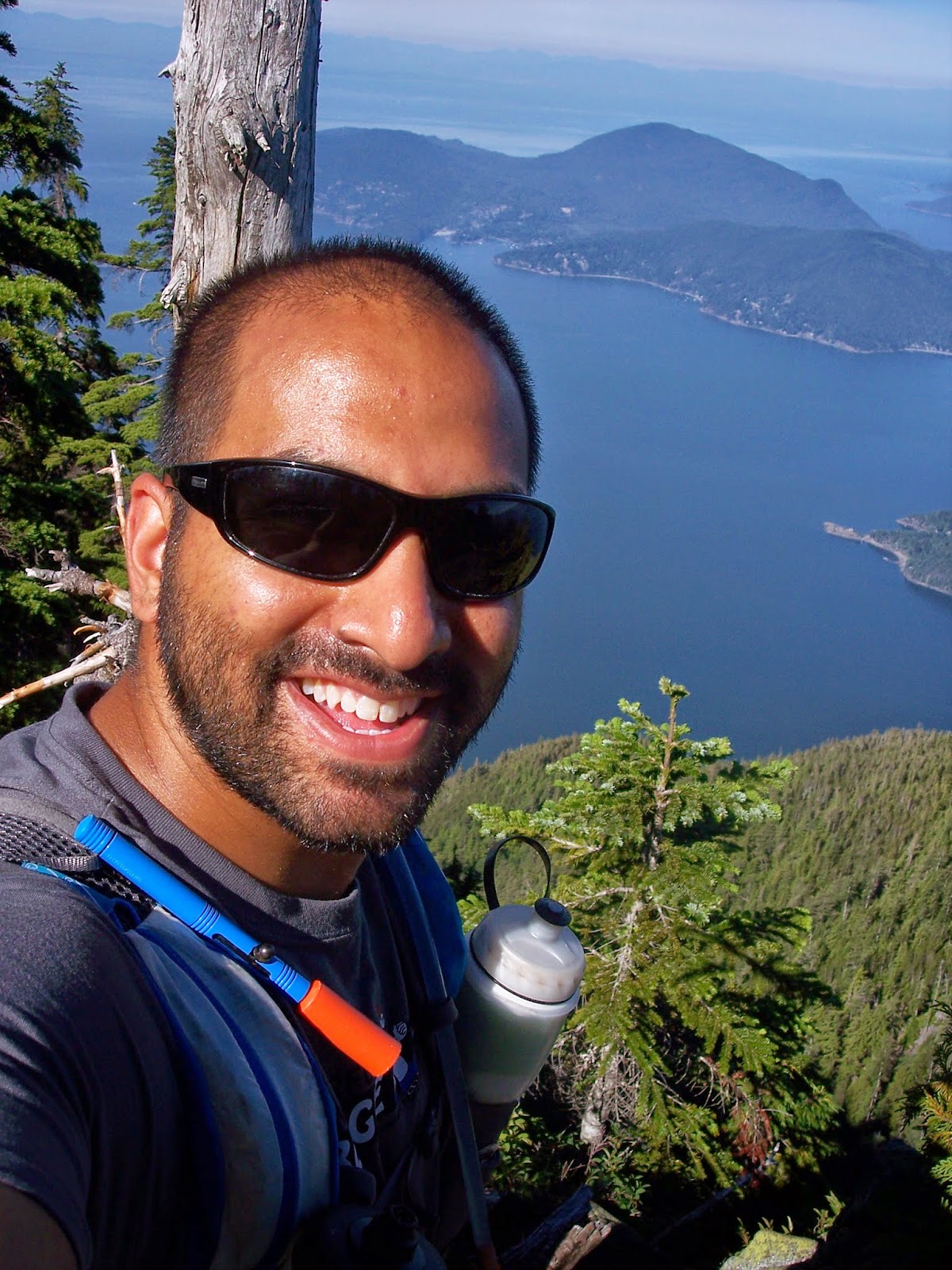 |
| Me with the view in the background |
 |
| View of Howe Sound from St. Marks |
 |
| Nani watching a raven at the top |
 |
| Sean & Nani just resting |
 |
| Lucky raven getting part of Kyndra's burrito |
From St. Mark's the trail headed over to Mount
Unnecessary, I always wanted to climb this peak mostly because of the
name. Along the way to Unnecessary we encountered another peak and named it Mezcal
Mountain. Once we reached the south summit of Unnecessary there was a
slight gully before reaching the north summit. Sean pointed out a
couple of small glacier lakes for us to take a dip in for the return
leg. Kyndra and Nani were thrilled about the idea of a swim. By now
the Lions were looking so close yet so far.
 |
| Wondering if it's possible to dive to the ocean |
 |
| South summit Mount Unnecessary |
 |
| Nani's chilling out in the snow |
 |
| Looking south at Indian Arm & Greater Vancouver, from Mount Unnecessary |
 |
| All smiles, we knew where we were heading |
 |
| Nani's proof, she was so excited she knocked over the sign |
I have made it to the base of West Lions a couple
times now (via Lions Bay) and always through you needed rock climbing
gear to reach the summit. I was informed by Sean that it is possible
to reach the summit without any special gear but you do need to be
very careful. So poor Nani would not get to bag the Lions peak. We
found a nice shady spot for Sean and Nani to relax while Kyndra and I
go bag the peak. We reached the base and a small gully was in our way
to get to the top. Kyndra looked down to assess the situation, she
said we could probably get down but not sure if we can get back up. Since she felt like it was not doable, I had to agree with her. So we
turnaround and headed back to Sean and Nani.
We almost reached them as we see Sean coming up
towards us, saying he's going to summit the peak. He's done the peak
before so I followed him up and left the ladies to nap in the shade.
We arrived at the gully that Kyndra and I turnaround at and I let
Sean lead the way. This little climb down was a good indicator of
what was to come. (NOTE: if you think the chimney at Black Tusk is
scary, you should not attempt this) After making it down to the small
gully we crossed over to the base of the peak and started heading up.
I'd recommend having some basic rock climbing skills from this point
on or a Sean with you. I followed Sean's path
very carefully and slowly. There were sections of “wide” and
narrow ledges along the way that we needed to traverse. (I'm using
wide very loosely here) We got to what I now call the rope
section.
The rope section is just a short 3 to 4 foot section,
where there is a loosely hanging rope that goes from one side to
another. The rope did not look like it would of been an easy option
to go from one side to another. Sean was able to go across with ease
so I followed. Finding footings was a challenge and when you look
down the drop was so long that you would need to stop screaming while
falling and take a deep breath and continue screaming. I have to
admit going from left to right was easier but more on that later.
Once we were over to the other side there was some much needed shade
with a vertical climb up that was a nice change from the death drop.
From this point on it was relativity “easy” climb up to the top.
There we took in the view before heading back down. Everything was
going smoothly until we were at the rope section again. Now going
across the other way I had a weird hold and couldn't get my foot
around a rock that was sticking out. I had to go back to safety and
try again. Sean guided me the whole way across this section without
any other issues. We slowly made our way back to the gully, the last
climb up to safe ground proved to be challenging for me just to get a
good hold on the rocks. Once on safe ground we high-fived each other
and ran over to see a sleeping Kyndra and Nani. We all hung out in
the shade and refueled for the trek back to Cypress.
 |
| Almost at the peak of West Lions, don't look down |
 |
| Quick picture up the peak |
|
 |
| Looking south at Indian Arm & Greater Vancouver, from West Lions |
 |
| Looking at East Lions and beyond |
 |
| Looking west at Howe Sound |
By now it was late afternoon and we started
bushwhacking through the alpine shrubbery towards the glacier lake.
Our first attempt we realized we were no where near the lake and
headed towards the north summit of Unnecessary were we back on the
trail. Along the way to the south summit we turned off again to
finally find our swimming spot. Nani was the first to take advantage
of the cool water. Shortly after Kyndra and Sean were in the water
going from one end to the other. I slowly waded in up to my shoulders
and enjoyed the coldness of the water. I have discovered that not
swimming since I was a kid has made going into water a bit of a
challenge. After our short dip, we packed up and headed up towards
the boulder field that would lead us to the trail. As we climbed up
the boulders a helicopter passed directly above us, I think they
were checking us out. There were a lot of air traffic all day for
some reason.


As we reached the top of the boulder field we heard
a bear bell, guy by himself was heading back to Cypress as well. We
wished him a good day and started over the south summit of
Unnecessary, shortly after we were already at Mezcal Mountain and
heading down the long decent. The downhill seemed endless on our
tired legs. Even Nani who was leading the pack at the beginning of
the day was now mid to back of the pack. Once we reached the bottom
we started our climb up towards St Mark's again. The climb seemed to
go relatively quick and as Sean pointed out I was not allowed to
complain since my race was in a month (that's a scary thought).
St Mark's Summit was beautiful in the evening with
about an hour and a half to go before we reach the parking lot at
Cypress we picked up the pace where we could and even got in a rest
break for Nani who was really struggling. During our break a couple
of runners passed us, hammering down the hill. Shortly after we got
up and started back down. Eventually seeing the runners that passed
us earlier. Sean let us know his intent to catch up to the runners.
Kyndra and Nani didn't want any part of that. So as Sean took off
running I followed. We ran every downhill and flat section, while
power hiking the up hill. About 1.5k from the parking lot we caught
up to the runners as they turned off towards a lookout. We waited
for Kyndra and Nani there for the walk back to the cars. After eleven
and a half hours of being on the trails, with scorching hot rocks,
cool alpine breezes, little patches of snow to help top off our water
and the beautiful views all around we got to the cars and enjoyed
some cold watermelon and Buddy Fruits. Thanks Kyndra to
introducing me to those delicious treats.


